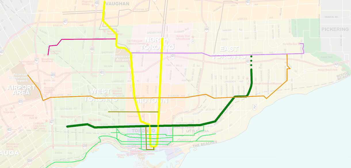
Not shown: 139 bus routes, which would make this entirely too complicated.

The Eglinton Crosstown LRT line in orange is intended to stretch from the LRT storage and maintenance facility in Mount Dennis on the west end, out to Kennedy Station in the east. It's slated to open in 2021. Originally envisioned as a subway in the 1970s, then started and cancelled in the 1990s, it's now so far along that cancelling it would be political suicide. It will replace about half of the busiest bus route in the city (Eglinton West), as well as the entirety of the 14th busiest (Eglinton East). It will be partially underground through the middle of the city, and at grade but in a separated right-of-way east of midtown.
Further north, the Spadina Subway Extension that was supposed to open before the 2015 Pan-Am games has been pushed back to the end of 2017. It will extend north of the city to Highway 7 in York Region, stopping at York University along the way. As with the Eglinton, this too is the culmination of a long-ago project that pooted out with a single extension to Downsview Station in the 1990s.
As the new Bombardier streetcars are delivered, the Spadina and St Clair lines that operate in separate right-of-way will become functionally similar to LRT lines with more frequent stops. They're highlighted in gold. Just as with everything else, these are behind schedule too. We should have had 73 cars by the end of 2015. Instead, Bombardier had only finished 13. As the old cars deteriorate, the TTC has cancelled service on one streetcar route, converted two others to buses, and two more to mixed-vehicle service. As buses have lower capacity, this is increasing operating costs and road congestion, and also delaying improvements to the bus system. Once the remainder of the new streetcars arrive, service will start on a new streetcar, the 514 Cherry running along King to the distillery district; a tiny spur just southeast of downtown.

Not shown here is SmartTrack, the brainchild of our current mayor. 1/4 of it, heading north-east into York Region has been postponed to "a later phase". He's admitted that another 1/4 of it is near-impossible, and has reverted to the original idea of a westward Crosstown extension to the airport as shown (All preliminaries done, they could theoretically break ground the day after funding is arranged.) Sooner or later the other half of SmartTrack will be dropped, as service on those rails is already provided by the regional transit authority - assuming responsibility and costs municipally for it would be disastrous. Even if it were flipped to municipal control, Union Station is incapable of handling the increased traffic he's proposing. It also becomes mostly redundant as soon as the Danforth extension and Downtown Relief Line are completed - shown later.
In the north-west, the Finch West LRT has completed all preliminary work and is looking for bidders to actually construct the line. It will extend from the Spadina extension west to Humber College, replacing a big chunk of the third-busiest bus route in the system.
The Scarborough RT is at the end of its lifespan and can't be renewed with new vehicles as-is since there are no suitable trains that can safely make the hard turn. Following much arguing, it was decided to extend the Bloor-Danforth green line into Scarborough. This was chosen over a light-rail solution. Originally to be three stations up to Sheppard Avenue, the mayor has hinted that he wants to clip the northern (dotted) portion, and eliminate one other intermediate stop. I actually believe that this compromise is the right decision to make in the short term. Serving the transit hub of Scarborough Town Center is the primary focus of the subway extension. The intermediate stop would have been lightly used, and the Sheppard stop is of limited use until there's rapid transit on Sheppard, but will need to be built eventually.
Using the savings, there would be a separate branch of the Crosstown east and north to the University of Toronto's Scarborough campus. This would essentially be completion of a line from the Transit City plan put forth in 2007-2012, which had completed most of the pre-construction work, so this might be able to open with the rest of the Crosstown, with some inefficiency involved in vehicles and drivers having to cross the city, until the planned east-end maintenance yard near the north end of the extension could be constructed.

First up, the Sheppard East LRT. Originally, the Sheppard Subway was to extend to Scarborough Town Center, where the Bloor Danforth extension will now be built. Despite anticipation of corporate development in the Sheppard-Yonge and STC areas, these became mainly residential areas, and funding for the subway dried up as there there isn't enough travel between the two for one. However, there is definitely a need for some rapid transit, hence the intent to build a LRT in about ten years, running from Don Mills subway station to the planned maintenance facility near Morningside Ave.
One look at this map reveals three glaring gaps in this plan: two are where obvious links could be made to the Bloor-Danforth and Crosstown lines. The third is a glaring problem with a lack of rapid east-west options in the mid-north part of the city. There is just not enough ridership to justify extending the Sheppard subway west from Yonge to Downsview, so the current plan is to leave this patchy. To cross the north end of the city, you would have to take 5 vehicles: the Finch LRT, the Spadina Subway, a bus to link from Downsview to Sheppard-Yonge, the Sheppard subway, and then the Sheppard LRT. (Or a bus to Yonge-Finch and the Yonge subway south.) Obviously, each transfer is an additional delay.

It is a lot easier to justify an LRT westbound for 4km. This should be fully-tunneled. Coming to the surface at Sheppard-Yonge would be disastrous given the heavy traffic in the area from people going between the 401 and Yonge Street. While it's possible from a traffic-flow standpoint to come to the surface at Bathurst, most of the expense of preparing boring sites and running the tunneling machines will have been undertaken already. Heading eastbound, I've added a slight at-grade extension to bring rapid transit to the Toronto Zoo. The Crosstown has also been extended the last 1.5km to close the loop, an extension so obviously neccesary I'm certain it will happen regardless - that intersection is where they intend to build a maintenance yard.
Also in the long-term planning stage is the Downtown Relief Line to ease the congestion on the Bloor/Yonge subway intersection. Every trick possible has been used to ease that station, and it will still be at absolute maximum capacity in about 10-15 years - it's well above comfortable capacity today. This has been considered high-priority for literally decades, and work has still not begun. The current word is that the biggest priority is to go from either Pape or Broadview stations down to King or Queen.
If it were up to me I would choose Broadview, for several reasons. It has 15% higher passenger flow to/from the trains, 2 streetcars and 4 bus routes served compared to Pape's 3 buses, and - I feel this is the deciding factor - it is closer to the Don Valley. Running a portion of the line along the Don Valley with noise baffles instead of in deep tunnels will save significant amounts of money.
Through downtown, I would choose King by a narrow margin. Queen St means access to the Eaton Centre and city hall, and as it was originally planned to be where the east-west subway was to be built before the Bloor-Danforth, there's already a roughed-out Lower Queen station, and fewer utilities to move. However, the DRL must reasonably serve the Distillery district to the southeast. A future westward expansion must unquestionably serve the CNE and Liberty Village, again, south. King St means less tunneling. The King streetcar also carries far more people per kilometer than the Queen, making this a higher priority to me. I've seen suggestions to use Richmond St to avoid conflicting with Yonge/University stations and streetcars during construction. Despite that advantage, the line once completed would be inconvenient, confusing to tourists, requiring a walk to get to any other transit or a revamp of surface routes downtown.
The problem is, if the DRL is stopped at the Bloor-Danforth as intended, the TTC estimates it will only buy about 6-7 extra years of capacity on Yonge. The DRL must extend at least as far north as Eglinton, ASAP, which still only gives us about 12 years' grace. The day that the Crosstown opens, Yonge/Eglinton will have a massive jump in traffic. A northward Don Mills extension relieves the Yonge line, the Don Mills bus (5th busiest), reduces all travel time from the east end, and puts a subway up to the Science Centre museum. This should be an even higher priority than the Sheppard East LRT, as that LRT will strain the Yonge Line even further by funneling people in the northeast down that corridor.
Having said that, given that we are already too late to build this before Yonge/Bloor is over capacity... let's stop debating what's best and get ANYTHING built!

Jane is the second-busiest bus route in the city right now - it will be #1 the day that the Crosstown opens. It obviously represents the best place to put a west-end North-South transit corridor. The routing I've listed is a direct copy of the Jane express bus, and must be tunneled until at least until Highway 401. It could then run tunneled or separated-at-grade from there to Finch, as Jane and Finch is where the maintenance facility will be. While this is a sizable investment, the southern portion's roadway is simply too narrow for a dedicated right-of-way, and mixed-traffic, streetcar-like operation would be unfeasible, unsafe, and wouldn't improve travel times.
A further extension north to York University would be preferable, and is shown on this map, but could be considered a second-phase project. Heading north to Steeles and back down is the best routing; entering the campus from the west side would mean a lot of expropriation and demolition of houses to link the LRT to the subway safely. A third option would be to end at the Pioneer Village station on Steeles, and have passengers transfer to the subway to link to the university.
Coinciding with the Jane LRT opening should be a St Clair streetcar extension to Scarlett Rd. A loop could be built a couple blocks north of St Clair in an undeveloped power tower corridor. While Jane would be the main purpose of the extension, the remaining 1km spur might even be the cheaper option considering the cost of obtaining land at Jane to build a loop. Operating costs of that extension would be partly offset by eliminating the redundant 79B Scarlett bus route branch that couldn't be eliminated with just a Jane St loop.

An alternate solution is to serve Dufferin station to take more of the strain off of the "Sufferin" Dufferin bus, which would see minimal improvement with a Dundas West DRL routing. Building the DRL station at Dufferin could include an underground footpath to Dufferin Mall, leaving the streetcar network to service Dundas West. Unfortunately, I still think Dundas West gives better bang for the buck.
Instead, I suggest a radical solution: converting the lower portion of Dufferin to a streetcar route south of Eglinton. It can't be an LRT, because the southernmost kilometer of Dufferin already has streetcar track and loop which is used as a short turn for both King and Queen streetcars, plus the upcoming Cherry Streetcar. Municipally owned land at Eglinton (Fairbank Station) could be turned into a loop easily enough. As a bonus, St Clair streetcars would have a shorter link between the west end and the maintenance yard compared to now. Dufferin streetcars on detour or short turn could use Dundas and College, plus the Lansdowne/St Clair loop, or a new loop could be built just north of Dufferin and St Clair where a municipally owned parking lot is now. The Dufferin bus' C branch to the CNE would be redundant because of the DRL, but could be run as a separate bus route from the southernmost loop if needed. The large disadvantage with this setup is that car traffic would be heavily slowed by the streetcars operating in the middle lane of mixed traffic. Unfortunately, Dufferin will soon reach the limits of what bus service can provide, and the only other reasonable option is a tunneled LRT, which would be redundant with the Spadina line so close in the north end.

What looks like a gap in subway coverage in the mid-west is actually made up by the Union-Pearson express, which is managed by the regional Metrolinx authority, but will eventually become integrated through use of Presto.
Yonge subway extension north to Richmond Hill Centre (Highway 7). This is actually already likely to happen in our lifetimes. The TTC even has preferred stops chosen. A hefty Downtown Relief line is an absolute must before this can be built, or congestion will be so heavy that passengers in midtown will be completely unable to board trains during rush hour. Current estimates are that if this extension opened now, Yonge would be completely full from about Eglinton or Lawrence in about 5 years.
Bloor subway extension west to Mississauga City Centre / Square One. This has also been bandied about from time to time. Square One is the busiest transit hub in Mississauga, but the cost-effectiveness is questionable given the amount of tunnel that would have to be built to reach it. Stations in between would be lightly used without heavy development there. It would also require a lot of negotiations about fares and funding between Toronto and Mississauga.
Finch LRT extension west to Pearson Airport. Already in the pre-planning stage as a Phase 2 expansion, it too crosses the city line and needs extra planning. Linking it with the Eglinton Crosstown would also be difficult as they will be approaching the airport from opposite sides. This is my best guess of one possible routing, limited by several highways and railways in the area.
Finch LRT extension east to McCowan and Sheppard. Metrolinx has suggested going just to Don Mills and then south. One reason that won't work: Seneca College, located at Finch and the 404. Buses are already close to capacity in that area. An LRT turning south at Don Mills would completely miss the college, which should have rapid transit in both directions. While we're building, it would make sense to link to the subway at McCowan. This isn't redundant despite proximity to the Sheppard LRT. Finch E and Sheppard E each carry about 25,000 passengers a day already and growing. This solution spreads the load and provides more travel options at a far lower cost than a full subway. For bonus points, the DRL could continue north to Seneca and into Markham, but this would be an expensive proposition needing consultation with York Region.
Crosstown extension north to Malvern Town Centre. This is a relatively short extension that would link a moderate population density neighborhood to rapid transit.
At this point, the year 2050 project list might include a Kipling or possibly Islington rapid transit line, and an Albion-Wilson, continuing east on York Mills and Ellesmere. In the east end, similar projects may be needed on Victoria Park, and a streetcar extension on Kingston Rd. There might also be a Crosstown conversion to put more of the line underground to increase speed and run longer trainsets more often. Those are just my best guesses based on land available - at this point, we're looking at a full generation of Torontonians growing up. The current population and transit patterns wouldn't support any of these initiatives.
